Sunday 31 December 2017

Caravaaan

Following on again on the CSIO trade theme, I got fed up with adding "if we assume that there's nothing off the west of the map" to any conclusions. So it was time to add the City State of the World Emperor - AKA Map 6.

The guidebook for map 6 isn't quite up to scratch in some aspects. Firstly, it has no "civ" rating for the settlements. Secondly, and rather more dramatically, it has no entry for the City State of the World Emperor (CSWE) itself! No population, no overall alignment, or civ rating. Nothing.

After a brief discussion on Dragonsfoot, I went with an "able bodied" population of 30,000, giving a total population of 120,000, and a civilisation rating of 10 - the max. For other settlements I rolled or picked a civ rating. I set the CSWE alignment as LE.

As an example of picking, I put the military settlements such as Moon Tower and Midwall at 0 on the grounds that they are not in fact producing anything at all and since civ is defined in the CSIO guide as being primarily a rating of manufacturing ability that seemed reasonable.

One thing that jumped out at me was how much lower the population levels on Map 6 are. Aside from the huge CSWE, only Targnol Port breaks the 1,000 level. There's nothing to rival the City State in the way that Warwick or Ossary do for the Invincible Overlord.

A consequence of this is that although the CSWE does end up with more trade that CSIO, it is not as big a gap as the guidebook seems to imply - just over 20% more. Since the CSWE has an estimated 50% more people in it, this means that on average they are poorer than their eastern counterparts, at least in terms of traded GDP. The specific values for the combined maps are 26 to 33.

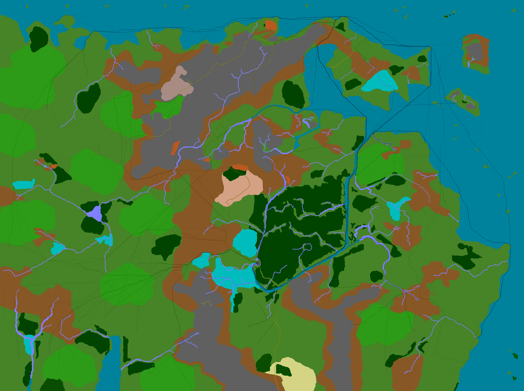
Here's the base map (light blue is withing 5 miles of land):

Are we there yet?

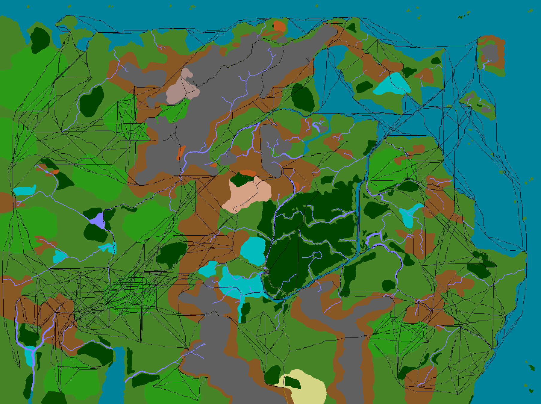
One big question was whether the main trade route from CSIO to CSWE would be by sea or land. Although the land route is shorter, the northern route past Warwick and into Quiff looked like it might work. As it turned out, it works for Warwick but it's too far for CSIO ships to compete with a mostly overland route.

That route runs west through Darkfield then across country, over the Battleplain Gwalion to cross the River Bucknol at the lower Quoth Crossing from whence another day and a half's march brings it to Caelam and the start of the Emperor's road network. Two days pounding pavement brings the route to the port of Augge where it embarks for the big city.

See sketch (click to enlarge):


The significance of this route to actual play, of course, is that it is the route that the annual tribute from the Overlord to the Emperor will follow - an event that is sure to be accompanied by much activity both in the wilderness and back in the city where many of the troops and higher level NPCs will be absent, assigned to protecting the caravan.

The trade from Warwick goes via Smitten, making it the 5th most important transshipment port on the combined maps (Augge is #1).

In terms of transshipment, Targnol is 15th and the city generally fails to live up to its billing as a major port, although it does come 4th in terms of trade volume. Augge is a much more important port. Adding the sparsely populated maps to the south won't change this, especially since those areas will sail directly to the port in CSWE itself.

Is This Making Sense?

As an almost final note on this subject, I would say that this examination of the trade routes and populations has confirmed what I had always felt about the setting: as demographics, it simply doesn't work. CSWE almost works in the sense that the are labelled "Emperor's Farmlands" is just big enough to support even a population of 120,000. Sadly, the city is not big enough, I think. Even with 5-story buildings of the sort the ancient Romans resorted to for packing the population of Rome into its footprint is probably not enough. The situation in CSIO is even worse. There's no way to fit 20,000 into CSIO, let alone the 80,000 total that the books suggest is the whole population including women, children, and the old.

Likewise, the lack of roads in the east means that getting food to CSIO from outlying settlements is pretty tough if the production is not hard by a river or the sea. With no equivalent to the Emperor's Farmlands, it's hard to see where the city's food is coming from. On the scale of the maps I've used, there is a need for 16,000 pixels of farmland (using JG's rules, which are not far off reality for the tech level). All the land west of the city between the hills, the Mermist, and the Troll Fens adds up to just under 6,000 pixels (60,000 acres). And that's not even open plain, it's "light woods". The city has no visible means of support.

The settlements of these two maps are very isolated from each other. There's very few towns that have more than one neighbouring settlement within a day's travel, at least for bulk trade purposes. As such, there's unlikely to be much shared culture and the "common tongue" will be very limited outside of trade subjects such as counting, quality, and dates. Discussions of ancient civilizations (and where to find them) is not going to be easy.

The length of trade routes means that caravans will be the norm, as overnight stops will be routine, and defensive measures absolutely vital. Likewise, the large towns will have to patrol wide areas to help keep much needed trade safe from gnolls, orcs, and dragons.

Ultimately, the Wilderlands is not about demographics, it's about adventure. This analysis is aimed at end-game factors for domain clearance. Where is the Overlord or Emperor likely to grant lands? What long-standing monster lairs would they want removed as part of such a deal? Where would the PC be able to offer colonists some economic future? And so forth.

The problems identified with the setting are really not too obtrusive and can even be handwaved away - the City States' listed high populations are perhaps just the total troops they can draw on across their whole domains; the cities themselves might be very much smaller. Perhaps magical food production allows the Overlord to feed his city.

Anyway, that's enough demographics for now. More religion next time.

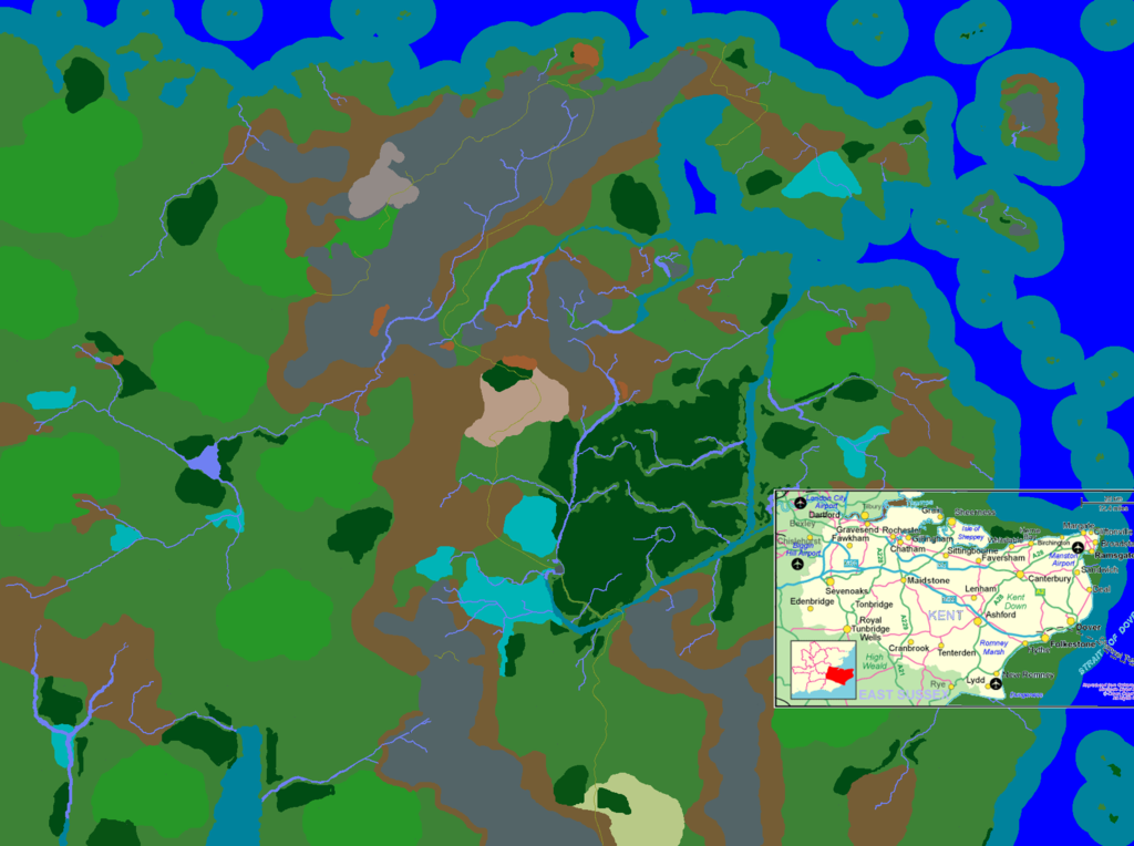
Oh, one last thing. I did some maps to the south to test whether Ossary would take that route (it did not). I've only really done the coasts so far but in case anyone wants it, here's the larger map:


Sunday 24 December 2017

How Wild are the Wilderlands?

The Road to Wildwood (0633)
Following on from last time, I had a look at the population density of Map 1. With 64347 "Able Bodied" people listed on the map, we get a total population of just 257388 people living in an area of 38,000m². That's just over 6¾ people per square mile.

In mediaeval England, just before the Black Death struck, there was probably about 4-5 million people living in that amount of space - at least 16 times more heavily populated.

There's not a huge number of countries today with population densities that low. Kazakhstan is slightly less and The Central African Republic (AKA The Congo) is a shade higher (see illustrative image). The UK value is 640/m², the U.S. is ~84, and even Canada is only half as populated as Map 1 of the Wilderlands which is itself the second highest population density of the 18 map set.

There is a certain amount of hidden population on the map as each marked settlement has some small but unspecified number of hamlets of 10-60 inhabitants, but that doesn't change the overall picture much.

So, yes, the Wilderlands are pretty damn wild and the trade routes shown in the previous post should be regarded in that light. Away from the handful of really busy lines between the big cities of Warwick, Sticklestead, the CSIO itself, and Ossary, trade is going to be light indeed.

Next time: does the JG Wilderness setting "make sense" as a demographic simulation and should we care? Hints: no and no.

Sunday 10 December 2017

Trade in CSIO

1 Introduction

I’ve been wanting to do this for a very long time indeed. The City State of the Invincible Overlord (CSIO) came out in the 70’s and a revised edition in 1980 or thereabouts. Over the course of several publications and 18 maps of about 38,000m² each, Judges Guild mapped out and gave basic population statistics for an area (“The Wilderlands”) about the size of modern Libya, or the UK, France, Germany, Italy, Poland, and a bit of Belgium put together.

One thing that was never clear to me was just how wild the “wilderlands” were. There’s not much in the way of roads, and the basic terrain is not open plains but light woods, with some plains interspersed. Did the towns marked trade with each other much? How dominant were the handful of city stats and how dependant on their satellite towns where they in turn? Where would a pirate or bandit lurk and by extension where would patrols be placed to protect the trade routes?

Around 1989 or so I bought a book - Settlements by Meyer and Huggett - in a Cancer Research charity shop which introduced me to Reilly’s theory of retail gravitation (from 1929). The idea was that trade between two settlements could be modelled based on the product of the populations divided by the distance between them raised to some power. Add in some constant multiplier to scale it to specific units and the resulting formula looks a lot like the standard Newtonian one for gravity, hence the name.

The specific reason I bought the book was that I thought that I could use it to somehow model the trade pattern in the Wilderlands of the CSIO. Nearly 30 years have passed since that day and finally I’ve gotten around to it! What can I say? I had a long list of things to do.

The catalyst for finally doing this was two-fold: firstly I had been nursing an idea for a path-finding algorithm for a couple of years which I had hopes for, not only for geographic path finding but for broader applications in code optimisation. Secondly, I stumbled across von Thünen’s model of the “Isolated City State” and how he showed a city state’s surrounding economic area could be seen to diverge from a theoretical model under the influence of terrain and transport factors, something I was seeing in my reading around mediaeval London and its trade patterns. I even found a couple of websites that demonstrated this with some limited path-finding algorithms.

One attractive aspect of von Thünen’s model was that it is essentially pre-industrial and focused on agricultural questions which were broadly applicable back into the mists of time.

2 Method

So, Reilly used distance, but what is “distance”? Straight line distance is clearly nonsensical; as von Thünen emphasised, the real distance should be measured in time. Since we’re dealing with D&D here, that meant looking at movement rates. But underlying this was a deeper question about the nature of trade. In the von Thünen model, different sorts of produce are segregated into bands around the city state, primarily by their perishability and this maps directly into Reilly’s theory where the power distance is raised to relates to the urgency of delivery. The obvious example is that fresh milk, especially before refrigeration, simply has to be produced near or in the city.

By extension of this idea, it’s clear that on the scale of the Wilderlands maps very little trade is done in such products and if the CSIO needs milk it must be producing it itself in the surrounding hex of farmland or getting from very close-by up the Twilight Road or down the Old South Road. In any case, such things would not make up a huge amount of the trade on the map as published, where roads are very rare indeed.

For the sort of bulk non-perishable goods I was thinking about - timber, grain, metals, wine etc. - the value drops of linearly. Which is to say that the value of the product is constant, at least on a time scale of a season or two, and profit is eroded as much by the costs of the fifth day on the road as it is on the first. For milk, the second day erodes profit much faster than the first, and by the fifth you’ve got nothing left to sell.

This makes Reilly’s power simply equal to one. Since I’m only looking at relative levels of trade I don’t need a constant to convert into units (yet), so the final version of the formula is just

trade=pop1*pop2/travelTime

and all I had to do was calculate the travel time between every city on the map (all 98 of them).

I looked at how to do this using the hex map. I tried a lot of things but eventually I had to admit that the hex map simply wasn’t good enough. Forests and especially rivers did not follow hex sides and trying to encode them as side data ballooned. Eventually I realised that “hexpath” would have to be come “pixepath”, and the map would have to be some sort of bitmap image where each pixel was given one and only one terrain value.

2.1 A Star is born, then dies, is reborn, and finally discarded

I had been mulling this path finding idea for a while. I have written a few chess playing programs over the years, including a Dragon Chess written in M68000 assembly, and had been struck by the whole idea of quickly finding a move, and then progressively trying to find a better move. If the first “guess” move is sensibly chosen then the search time is drastically improved as candidates can be discarded early.

What, I thought, if we took a direct line from Point A to Point B over a map as a first guess, and then tried to refine it from there?

I constructed a test map and gave it a go. Well, to cut a long story short, it didn’t work. Looking back, I was gradually approaching the correct answer but my biggest problem was actually the direction of travel. Going from start to finish, my algorithm was constantly tripping over itself because the square it had “come from” at each step was not itself in a resolved and final state so it ended up looping over and over again. Adding flags didn’t help as that left the previous square as an unknown, preventing any objective early cutting out of paths by comparing them to the first guess.

I gradually started peeking at the Internet for help and found the A* algorithm. This is based on Dijkstra’s algorithm and like his it starts at the end and works backwards. Since the search starts with an objectively completed square (the destination, who’s cost is by definition known to be zero), it avoids the problem of tripping over its own tail and can always complete.

So I redid the code to use A* and things were good. For a while.

As it turns out, A* is a very fast way to find the distance between two points. But to find the distance between 97 points and a 98th, it’s not so hot. In my earlier code I had cached a lot of data in the hope of re-suing it, but A* doesn’t do that, so each run through starts from nothing again. For my code, once there were about 7 cities on the map, A* was getting slow.

Once I switched from a small test map to the map included in the code, which is 1807x1349 (8px = 1 mile), with lots of terrains, A* died a death. Going back to Dijkstra’s original algorithm, I realised that it in fact caches the whole map. Once Dijkstra’s has run once the output is the cost of moving from any point on the map to your chosen city. This means that finding the route from Thunderhold to CSIO takes 3 minutes - much longer than A* - but those three minutes also get you the distance from every other city and point on the map. Over all, this is a huge advance over A*.

2.2 Drunken Sailors, not Bee-lines

The first runs with the code generated trade routes all right. But they didn’t look very realistic. Partly this is because Dijkstra’s algorithm is known to behave slightly odd on a grid like a bitmapped image, but also because the transition between two pixels of light wood, or between light wood and open plain, always costs the same. So the trade routes were all made of horizontal, vertical, or 45° lines.

Adding a small pseudo-random factor to the cost of each square had a much larger effect than I had expected and the routes now look quite good, although not perfect.

2.3 Plains, Boats, and Roads

The next problem was that everything went by boat as far as possible. It’s certainly true that river and sea trade were extraordinarily important for mediaeval trade and one thing that modern people really don’t appreciate as they fly along the motorway at 70+mph is the humble bridge.

Until the 13th century, Britain had a massive shortage of bridges over rivers. If you have a one-ton cart being pulled by a couple of horses, even quite a small stream was an obstacle. If you were using oxen it was even worse as their short legs meant they would drown in a stream that a man could probably wade across.

So, yes, rivers should be important but they were insanely so when I first started to add significant numbers of towns to the map. The solution was to think more about what was being modelled: bulk goods.

One does not simply throw a ton of goods onto a barge and demand to be taken to Modor Modron. You generally have to wait for the tide, the ship to be ready, perhaps for other goods to be loaded up etc. So there’s a delay. There’s also a delay at the other end, albeit a smaller one.

Similarly, where an adventuring party might simply build a raft and enter a river or even the sea almost anywhere, if they needed to, 10cwt of barley needs something more sophisticated. So, rivers became a barrier again, except at settlements. And at settlements, the assumption is that on average goods set off on the boat/ship/barge, the day after they arrive, and 6 hours are needed to get unloaded and underway at the other end.

Cobbling together transport is still possible but it’s madly expensive. Similarly, switching from or to river transport at a ford can be done but it takes a week.

Finally, there is an assumption that the boats in question are quite small and do not handle the larger swell of the open sea as well as they do the more sheltered areas near the coast, so movement rates for the former are reduced. At the moment, I’ve defined (using the map) “open sea” to be anywhere more than 5 miles from any coast.

Movement aside from the special delays for transshipping is defined using D&D scaled inches so that it’s easy to relate to. Normal overland movement in D&D is 2xMv. So, a move rate of 12“ translates to 24 miles per day. I’ve pre-calculated the 2x part in order to allow some finer-grained rates as shown in the code snippet below:

\ These values are effectively 2 x the normal D&D move rates
+terrain impassible
infinite impassible self!
32 " opensea  \ slightly more risky, so avoid if possible
18 " city
48 " coastal
18 " plains
 9 " woods
24 " roads
12 " ltwoods
 9 " hills
 6 " wdhills
 1 " mts
 1 " swamp
 6 " desert
 4 " scrub
 6 " rough
30 " river
12 " ford
1 " jungle
4 " snow

I’ve not used snow yet. Note that the order of these terrains matches, and defines, the code used in the bitmap, so impassible is zero, open-sea is 1, city is 2 etc. When the program starts up it displays the combined movement table, which looks like this at the moment (probably best in the print-friendly version):

    opensea city coastal plains woods roads ltwoods hills wdhills mts swamp desert scrub rough river ford jungle snow
1 opensea 15 960 12 53760 53760 53760 53760 53760 53760 53760 53760 53760 53760 53760 15 53760 53760 53760
2 city 3840 26 3840 26 39 23 33 39 53 253 253 53 73 53 3840 33 253 73
3 coastal 12 960 10 115200 115200 115200 115200 115200 115200 115200 115200 115200 115200 115200 13 115200 115200 115200
4 plains 53760 26 115200 26 39 23 33 39 53 253 253 53 73 53 115200 33 253 73
5 woods 53760 39 115200 39 53 36 46 53 66 266 266 66 86 66 115200 46 266 86
6 roads 53760 23 115200 160 36 20 30 36 50 250 250 50 70 50 115200 30 250 70
7 ltwoods 53760 33 115200 33 46 30 40 46 60 260 260 60 80 60 115200 40 260 80
8 hills 53760 39 115200 39 53 36 46 53 66 266 266 66 86 66 115200 46 266 86
9 wdhills 53760 53 115200 53 66 50 60 66 80 280 280 80 100 80 115200 60 280 100
10 mts 53760 253 115200 253 266 250 260 266 280 480 480 280 300 280 115200 260 480 300
11 swamp 53760 253 115200 253 266 250 260 266 280 480 480 280 300 280 115200 260 480 300
12 desert 53760 53 115200 53 66 50 60 66 80 280 280 80 100 80 115200 60 280 100
13 scrub 53760 73 115200 73 86 70 80 86 100 300 300 100 120 100 115200 80 300 120
14 rough 53760 53 115200 53 66 50 60 66 80 280 280 80 100 80 115200 60 280 100
15 river 15 640 13 115200 115200 115200 115200 115200 115200 115200 115200 115200 115200 115200 16 26880 115200 115200
16 ford 53760 33 115200 33 46 30 40 46 60 260 260 60 80 60 26880 40 260 80
17 jungle 53760 253 115200 253 266 250 260 266 280 480 480 280 300 280 115200 260 480 300
18 snow 53760 73 115200 73 86 70 80 86 100 300 300 100 120 100 115200 80 300 120

These costs are scaled to the 1px=1furlong of the bitmap. Notice that it’s not symmetrical: going from city to river costs 3840 movement points, and from river to city costs 640.

When considering these movement rates bear in mind that they’re for a horse-drawn wagon when on land.

2.4 Hard Border

The biggest limitation of what I’ve done so far is, of course, the map edge. The results below all assume that there is nothing beyond the map, including the western edge where of course the City State of the World Emperor lies.

2.5 Moving House

Beyond adding in a “wooded hills” terrain in a couple of places, the main changes I made to the map was to move some of the towns to more logical places. I never moved any outside of their own hex but, for example, Seasteadholm was moved to the coast instead of being a couple of miles inland. I assume the cartographer had to fit the symbols into the map and there wasn’t always room when there were also wood’s rivers, and coastal cliffs to show. Similarly, if a settlement is elven and there are woods in the hex, I moved them into the woods at least a bit.

2.6 Here Don’t Be Dragons

The biggest lack of this iteration of the code is the lack of monsters and castles. In some way, both of these should affect trade. Both are given in the guidebooks but their effect must be based at least partially on movement - a group of ogres three miles away across water is unimportant, while the same group by the side of a road is going to have an impact on trade. Castles may reduce the effect of monsters, but may also impose their own tolls.

Given that the 98 towns require something like 5hrs to analyse at the moment, this is going to have to wait.

3 Other Factors

Once the raw data was calculated, giving a basic figure for the trade between two settlements, a couple of other factors were added in which Reilly probably didn’t spend much time on: race, alignment, and civ (tech) level.

3.1 Race

The race relations were based on the tables in PHB and DMG with some fiddling to join them together, as well as the addition of balrogs - a feature of the wider CSIO. The letters used in the game (P, G, T etc.) were mapped to specific multipliers (100% for prefer-ed,; 32% for hated; 10% for feared, a new category).

100 constant p
95 constant g
86 constant t
71 constant n
55 constant a
32 constant h
10 constant f

\ dw el gn  he  hb  ho  hu  gl  go  og  or  ba
p , a , g , n , g , h , n , h , h , h , h , f , \ dw dwarf
a , p , t , g , t , a , n , a , a , h , h , f , \ el elf
g , t , p , t , g , h , n , h , h , f , h , f , \ gn gnoll
n , p , t , p , n , a , t , a , a , h , h , f , \ he half-elf
g , g , t , n , p , n , n , f , h , f , f , f , \ hb hobbit
h , a , h , a , n , p , t , n , t , g , h , g , \ ho half orc
n , n , n , t , n , n , p , a , a , h , h , f , \ hu human
h , h , h , h , h , h , a , p , a , g , t , g , \ gl gnoll
h , a , h , a , h , t , a , a , p , h , n , g , \ go golin
f , f , h , f , a , t , t , t , a , p , t , n , \ og ogre
f , f , h , h , a , g , t , n , t , g , h , g , \ or orc
h , f , h , f , n , g , t , n , g , n , g , p , \ ba balrog

Since the race relations are not symmetrical, they’re calculated for each side of the trade and combined, so that if trade occurs between orcs and goblins the overall modifier is .95*.71=67.45% of normal.

3.2 Alignment

Alignment is handled the same way but the percentages were loosely based on the loyalty modifiers in the DMG. On that note, I resolved the question about “1 step, 2 steps, 3 steps” by ruling that changing any letter to N was one step, but that someone at N could move to any alignment in a single step. So LG->LE is two steps (LG-LN->LE) but LG to CE is three (LG->NG->N->CE). Fudge-a-rama.

create aligntradetab
\ N    LG  NG   CG   CN   CE   NE   LE   LN
85 , 100 , 85 , 80 , 75 , 65 , 70 , 90 , 95 , \ N
70 , 100 , 85 , 65 , 50 , 30 , 35 , 75 , 95 , \ LG
85 , 100 , 85 , 80 , 60 , 50 , 55 , 75 , 80 , \ NG
70 ,  85 , 85 , 80 , 75 , 50 , 35 , 55 , 60 , \ CG
85 ,  85 , 70 , 80 , 75 , 65 , 55 , 75 , 80 , \ CN
70 ,  65 , 50 , 65 , 75 , 65 , 70 , 75 , 60 , \ CE
85 ,  85 , 70 , 65 , 60 , 65 , 70 , 90 , 80 , \ NE
70 ,  85 , 50 , 45 , 40 , 50 , 70 , 90 , 95 , \ LE
85 , 100 , 70 , 65 , 60 , 50 , 55 , 90 , 95 , \ LN

Generally, people trust Lawful and Good -types most, and Neutrals are suspected a bit by everyone.

3.3 Civilisation Level

Each town is given a civ rating in the guidebooks and I’ve modelled this by simply them together, adding 1, and then multiplying trade volume by that. So a civ 8 trading with a civ 5 gets a 14x multiplier while a civ 9 trading with civ 9 gets an 19x multiplier.

The median civ rating seems to be about 5, so x11 (5+5+1) is the “normal” rating.

4 The Results

4.1 Trade Routes

This was the original target question: what are the trade routes? The current base map is (note: these maps are not opening when clicked on but if you select "Open in new tab" you should get the full-res versions):

https://raw.githubusercontent.com/tworthington/csiotrade/master/map1.bmp

Overlaying trade routes, with the boldness of the route being proportional to the amount of trade, gives this (open sea removed for clarity:

map1-trading.png

Figure 1: Graduated Trade Map

Here’s the same map but with the routes shown at the same boldness regardless of the amount of traffic:

map1-trading-sharp.png

Figure 2: Un-Graduated Trade Map

The next map is one that relates mostly to von Thünen’s model a bit more. This is a graduated tint overlaid on the map and centred on the CSIO itself, each step from light to dark indicating one day’s travel to the city.

I’ve pushed the bounds of copyright here to allow some of the original map to show through under my coloured version and the tint.

map1-csiodays.png

Figure 3: Days Travel To CSIO

It’s worth looking at this map for a while and visualising how much you know about places that are 5½ days travel away from you - the distance that Thunderhold is from CSIO. Assuming that you can think of anywhere that would take 5½days to get to in the modern world!

The final map is just for interest and superimposes a map of Kent on Wilderlands map 1 to show the scale. Basically, each Wilderlands map covers an area of 24.3 million acres (38088m²), which is about ¾ of the size of England.

kentish.png

Figure 4: Kent for scale

4.2 Trade Volumes

Trade is measured in arbitrary units for now and the program captures two main numbers for each settlement: the amount of external trade it engages in itself, and the amount of trade which passes through it on the way to somewhere else.

Since each town has a listed population we can translate these numbers into a measurement of wealth, even if we don’t have a specific ratio to convert it into gps. Another obstacle to making too much of these numbers - creating a measure of GDP - is that these numbers are all for external trade and don’t capture anything at all about internal trading within each town.

Taking tax on passing trade at a rate of 5% (1 shilling per pound) and adding it to the main trade figure gives the following table ordered by total income per person:

City Trade Per Person Via +tax
Darkfield 21199 121 117863 149
Haghill 7150 47 54507 63
Sea Hill 11342 38 153155 62
Modron 59829 48 59973 48
Bier 7187 42 7187 42
Thelamie 5778 35 21603 40
Croy 18179 39 18179 39
Brushwood 4614 34 4614 34
Wolfstone 13457 33 13457 33
Sticklestead 81295 32 82366 32
Woe 8431 31 8431 31
Seastrand 12553 30 12553 30
Ottersgild 5460 29 5460 29
Dearthmead 9288 29 9288 29
Zarthstone 12170 29 12823 29
Tain 11034 27 16507 28
Armagh 7741 28 7741 28
Fireside 9373 28 9373 28
Luckstone 6270 27 6270 27
Warwik 259121 27 259121 27
Anvil 4846 26 4846 26
Goodhap 5726 26 5726 26
Smitten 10539 22 25241 24
Tegal 5340 23 10672 24
Byrny 10923 23 22016 24
Muskholm 8985 23 8985 23
Rockhollow 4821 22 4821 22
Gaehill 9021 22 9021 22
Oakenbridge 6847 21 14383 22
Swarin’s Cairn 3211 20 5226 21
Flint 6264 21 6264 21
CSIO 435882 21 435939 21
Ryefield 2773 21 2994 21
Omen 4500 19 15445 21
Mill Haven 3713 19 5869 20
Shewolf 3276 20 3276 20
Sea Rune 2591 19 2742 19
Troth 3523 19 3796 19
Dorn 4259 18 4259 18
Thunderhold 36340 18 36340 18
Orlage 2894 17 7012 18
Foremost 5957 17 5957 17
Bernost 8304 17 8304 17
Carmage 3931 16 3931 16
Greybeard 7277 16 7277 16
Sunlitten 7429 16 7440 16
Limerick 2230 14 4288 15
Finmark 4510 15 4510 15
Lakenheath 8126 15 9226 15
Wormingford 1751 10 20486 15
Heatherbush 2883 14 2883 14
Bulwark 4267 14 4267 14
Hlymadle 4887 14 4887 14
Varin’s Firth 6304 14 6331 14
Ossary 47768 14 47777 14
Benobles 3859 14 4775 14
Irungsway 2501 13 2501 13
Springle 5081 13 5081 13
Landmarch 5904 13 5904 13
Red Cliffe 1568 12 1599 12
Ashenshaft 5372 12 5445 12
Charnock 5795 12 5795 12
Seasteadholm 1889 12 2037 12
Hankam 2031 11 2031 11
Hel 5131 11 5131 11
Bondmaid 1953 11 2094 11
Atwan 3266 10 3266 10
Hindfell 3362 10 3365 10
Elixer 4188 10 4188 10
Boughrune 2154 9 2154 9
Guilding 2809 9 2809 9
Doom 3028 9 3028 9
Caelam 4432 9 4432 9
Catalan 4604 9 4604 9
Shavenoar 1192 8 1192 8
Serpeant Little 1209 8 1209 8
Havocia 1313 8 1313 8
Jasonyria 2110 8 2110 8
Karn 2296 8 2296 8
Goblin Hill 3817 8 3817 8
Grita Heath 810 7 810 7
Smite 2404 7 2404 7
Anguikan 2975 7 3031 7
Lightelf 3057 7 3057 7
Elf-burn 975 6 5122 7
Forecastle 939 6 939 6
Adderwood 1873 6 1873 6
Palewood 571 5 571 5
Sunfells 2280 5 2280 5
Hunwood 2615 5 2615 5
Wildwood 741 4 741 4
Ered Chimera 1032 4 1032 4
Crucible 521 3 521 3
Hledra 799 3 799 3
Trollslore 486 2 486 2
Wenlock 608 2 608 2
Skaney 742 2 742 2
Dart 293 1 293 1

Re-arranging the table to give the top 20 cities by raw trade gives us:

City Trade PP +tax
CSIO 435882 21 21
Warwik 259121 27 27
Sticklestead 81295 32 32
Modron 59829 48 48
Ossary 47768 14 14
Thunderhold 36340 18 18
Darkfield 21199 121 149
Croy 18179 39 39
Wolfstone 13457 33 33
Seastrand 12553 30 30
Zarthstone 12170 29 29
Sea Hill 11342 38 62
Tain 11034 27 28
Byrny 10923 23 24
Smitten 10539 22 24
Fireside 9373 28 28
Dearthmead 9288 29 29
Gaehill 9021 22 22
Muskholm 8985 23 23
Woe 8431 31 31

4.2.1 CSIO

There’s not much to say about the City State itself. As expected, it is the largest economy and it draws in some trade from basically everywhere on the map. The biggest trading partner is Warwik at 26.2% of all trade. Here’s the whole list, down to those with 0.1% share:

City % CSIOTrade
Warwik 26.2
Sticklestead 7.6
Modron 6.0
Darkfield 4.3
Ossary 4.2
Thunderhold 3.8
Tain 1.6
Woe 1.5
Croy 1.5
Haghill 1.4
Dearthmead 1.4
Bier 1.4
Gaehill 1.3
Byrny 1.1
Luckstone 1.1
Seastrand 1.1
Sea Hill 1.0
Fireside 1.0
Lakenheath 0.9
Flint 0.9
Goodhap 0.9
Wolfstone 0.9
Foremost 0.8
Varin’s Firth 0.8
Smitten 0.7
Zarthstone 0.7
Oakenbridge 0.7
Charnock 0.6
Springle 0.6
Landmarch 0.6
Bernost 0.6
Bulwark 0.6
Omen 0.6
Muskholm 0.6
Rockhollow 0.6
Sunlitten 0.6
Armagh 0.6
Greybeard 0.5
Hlymadle 0.5
Goblin Hill 0.5
Hel 0.5
Dorn 0.5
Ashenshaft 0.5
Caelam 0.4
Shewolf 0.4
Anvil 0.4
Atwan 0.4
Carmage 0.4
Ottersgild 0.4
Brushwood 0.4
Tegal 0.4
Finmark 0.3
Elixer 0.3
Hindfell 0.3
Catalan 0.3
Anguikan 0.3
Hunwood 0.3
Troth 0.3
Thelamie 0.3
Limerick 0.3
Ryefield 0.3
Guilding 0.3
Benobles 0.3
Mill Haven 0.3
Jasonyria 0.2
Irungsway 0.2
Hankam 0.2
Doom 0.2
Bondmaid 0.2
Smite 0.2
Sunfells 0.2
Orlage 0.2
Adderwood 0.2
Boughrune 0.2
Wormingford 0.2
Heatherbush 0.2
Lightelf 0.2
Swarin’s Cairn 0.2
Sea Rune 0.2
Havocia 0.1
Shavenoar 0.1
Wildwood 0.1
Red Cliffe 0.1
Karn 0.1
Elf-burn 0.1
Seasteadholm 0.1
Serpeant Little 0.1

4.2.2 Warwik

Yes, so. Warwik. No one ever talks about Warwik, but it’s one of the biggest cities in the whole setting, not just Map 1. Bigger than Tarantis, bigger than Valon by miles. It dominates the north coast and the only reason it is not more important as a trading partner is that the map ends just north of it.

As it is, it has more trade per person than CSIO and has a higher civ rating too.

4.2.3 Modron

Much smaller than Warwik, or even Ossary, the model used doesn’t, I think, give Modron due consideration for potential tax collection from passing vessels but since they don’t literally pass through the town the program doesn’t catch them. Even so, it has the second highest ratio of direct trade to population, after Darkfield, and on that measure the citizens are more than twice as wealthy as those of the CSIO.

City % Modron Trade
CSIO 44.4
Warwik 18.5
Sticklestead 12.7
Ossary 2.8
Croy 1.3
Seastrand 1.0
Thunderhold 0.9
Brushwood 0.8
Wolfstone 0.7
Byrny 0.5
Zarthstone 0.5
Fireside 0.5
Sunlitten 0.5
Armagh 0.5
Smitten 0.4
Tain 0.4
Varin’s Firth 0.4
Ryefield 0.4
Oakenbridge 0.4
Greybeard 0.3
Flint 0.3
Muskholm 0.3
Sea Hill 0.3
Hel 0.3
Rockhollow 0.3
Ottersgild 0.3
Ashenshaft 0.3
Tegal 0.3
Charnock 0.2
Finmark 0.2
Lakenheath 0.2
Bernost 0.2
Gaehill 0.2
Darkfield 0.2
Anvil 0.2
Dearthmead 0.2
Woe 0.2
Troth 0.2
Thelamie 0.2
Dorn 0.2
Benobles 0.2
Caelam 0.1
Springle 0.1
Hlymadle 0.1
Elixer 0.1
Hindfell 0.1
Landmarch 0.1
Catalan 0.1
Foremost 0.1
Smite 0.1
Omen 0.1
Orlage 0.1
Shewolf 0.1
Haghill 0.1
Goodhap 0.1
Luckstone 0.1
Ered Chimera 0.1
Atwan 0.1
Bier 0.1
Karn 0.1
Carmage 0.1
Limerick 0.1
Seasteadholm 0.1
Boughrune 0.1
Guilding 0.1
Wormingford 0.1
Heatherbush 0.1
Mill Haven 0.1
Lightelf 0.1
Swarin’s Cairn 0.1
Sea Rune 0.1
  1. Pareto Curves

    The question naturally arises from the above observation as to how the uppermost members of society compare between the CSIO and Modron, given that the (external trading) economy of the former is 7¼ times the latter.

    If we use an 80/20 split (80% of wealth is owned by 20% of people) then we get the top 20% of Modronites are sharing 47863 between them, which is 129.7 units each. The same calculation for CSIO gives 348705 to the top 20%, which is 87. When looking at percentages this disparity holds, but for the CSIO the number of people sharing that wealth is much higher and the true picture comes out when looking at it from that PoV.

    So when we look at the top 20 people in each place, the difference between the two cities’ elites is clearer. For Modron these people represent 1.6%, whereas for the CSIO they represent 0.1%. The 20 Modronites have 1695 units of wealth each, the City Staters average 8405 units each.

    Ultimately, the top guy in Modron can expect to control 22424 units of trade while the Overlord grabs 111204 (assuming that the Overlord is as content to share as Anoethin is).

    I’ve glossed over many questions here, not least of which are what slope to use for the Pareto calculation and how applicable it is to very small numbers of people in autocratic societies. Not to mention that populations listed in the guides are for able-bodied men of fighting age, not full populations. Perhaps "top families" would be a better way of looking at it.

4.2.4 Ossary

Although Ossary is big and technically advanced (civ 8), its alignment of CE costs it a lot of trade. Still, it dominates the southern area to a degree which can only increase once Map 2 is added. The largest city there, Antil, is just over ⅓ of the size of Ossary and somewhat backward with a civ rating of 4.

City % Ossary Trade
CSIO 39.0
Warwik 23.5
Sticklestead 5.8
Modron 3.5
Croy 1.6
Swarin’s Cairn 1.4
Sunlitten 1.1
Sea Rune 1.0
Oakenbridge 0.9
Heatherbush 0.9
Mill Haven 0.8
Lightelf 0.7
Smitten 0.6
Armagh 0.6
Varin’s Firth 0.5
Hel 0.5
Seastrand 0.5
Tegal 0.5
Greybeard 0.4
Bernost 0.4
Catalan 0.4
Byrny 0.4
Muskholm 0.4
Tain 0.4
Zarthstone 0.4
Wolfstone 0.4
Guilding 0.4
Ashenshaft 0.4
Caelam 0.3
Lakenheath 0.3
Dearthmead 0.3
Thunderhold 0.3
Woe 0.3
Thelamie 0.3
Rockhollow 0.3
Ottersgild 0.3
Dorn 0.3
Wormingford 0.3
Serpeant Little 0.3
Charnock 0.2
Finmark 0.2
Hlymadle 0.2
Hindfell 0.2
Landmarch 0.2
Gaehill 0.2
Flint 0.2
Darkfield 0.2
Anvil 0.2
Goodhap 0.2
Karn 0.2
Fireside 0.2
Benobles 0.2
Jasonyria 0.1
Irungsway 0.1
Springle 0.1
Elixer 0.1
Doom 0.1
Hunwood 0.1
Foremost 0.1
Smite 0.1
Sunfells 0.1
Orlage 0.1
Shewolf 0.1
Haghill 0.1
Ered Chimera 0.1
Troth 0.1
Atwan 0.1
Bier 0.1
Sea Hill 0.1
Limerick 0.1
Seasteadholm 0.1
Boughrune 0.1
Ryefield 0.1
Forecastle 0.1
Palewood 0.1

4.2.5 Darkfield

Being on the road to CSIO as well as being physically close to it gives Darkfield a huge boost without being too incompatible on race, alignment, or civ.

4.2.6 Haghill

Like Darkfield, Haghill is near the city and gets a bigbump from that despite being small and undeveloped.

4.2.7 Sticklestead

Sticklestead is another large settlement that doesn’t get much of a look in, although an official scenario dealing with the area did come out in 2010(!). Bigger than Modron, it’s important because it allows access to the river and thereby to the sea, CSIO, and Warwik. I’ve also given it a bridge and a ford over the local rivers.

5 So what?

What to do with all this information? Well, the trade route maps show, for example, that Wormshead point is a good place to go a-pirating, and a place to send patrols to prevent it. There’s a line of small islands south of Croy which might make interesting bases for this sort of activity too, if the keyed encounters are not enough to put the players off.

The same goes for the land, with various crossroads apparent where PCs can prey on caravans, hire on to protect them, or where the DM can place inns or similar out-of-town bases.

PCs hired to locate lost cargoes or kidnapped merchants may be able to use their wits to learn of likely places to start a search.

The major cities will have rivalries and intrigues aimed at getting an economic advantage. Guilds from the cities will do likewise.

The information gives some idea of how likely it is to be able to learn something by locating a native traveller. So, finding someone from Warwik won’t pose too much trouble in most locations near the sea but finding people from Tegal to ask about its manor might be hard.

Even Thunderhold has only a 3.8% share of the City State’s trade.

There will be other uses, but for now I need to look at making the code multi-threaded so that I can hope to tackle adding on at least Map 6 and see what that does to the trade routes to the west.

All the Forth code is on Github (https://github.com/tworthington/csiotrade)

Sunday 2 July 2017

Sunday 18 June 2017

The Temples of the City State of The Invincible Overlord

Introduction

This is the first post in an experiment to see if I can convert the temples of the City State of the Invincible Overlord into the religious outline from the previous post. The version of CSIO is the second edition from 1980 so there’s a few difficulties. The first one is that this edition was part-way between LBB D&D and AD&D. So the range of deities in the city includes some from GD&H as well as ones which were included in D&DG. Indeed, the gods of the city state are an interesting mix of major and minor, multi-planar, and local with a range of characteristics which makes it an interesting challenge to fit into any single framework.

Another point is that the alignment system in the 2nd edition seems to be a 5-point system with LG, CG, LE, CE, and N only. There are hints in the text that the authors wanted this or that NPC to be, say, LN - in particular, the overlord himself - and that applies to the gods as well. I’m going to try to represent the full AD&D 9-point system in this series of posts but I’m sticking to my stance of eschewing Concordant Opposition, although I will revisit it in the future.

So let’s get started:

The Temple of the Gargoyle

This temple is an example of a Holy of Holies. Indeed, an extreme example as the god physically dwells here and nowhere else.

The Gargoyle, Arghrasmak, is a demi-god of some sort from the Elemental Plane of Earth and is only worshipped in the city and the nearby area.

All the normal clerical spells can be obtained here up to 5th level, the highest that Arghrasmak is able to grant.

Symbol is a grey sphere held in a black claw. Clerical mace heads are normally in this form.

Goals

As a chaotic, the Gargoyle dislikes the rule of law and has become a sponsor of thieves in the city. As an evil chaotic, he encourages the more aggravated cruel sorts of theft in order to increase suffering.

As an elemental his interests are in things from the ground - gold, silver, jewels, and loves to accumulate these for no more reason than he likes them.

Beyond these things, Arghrasmak has little interest in the mundane world and spends most of his time sleeping and plotting the eventual overthrow of those who forced him from his border kingdom in the Inner World, as he calls the Plane of Earth. Anything which increases his standing amongst the denizens of that place will gain favour.

He is dangerous to attempt to deal with and his word, although rarely given, is seldom honoured. He really only wants the treasures of the underworld. Worship is nice but the clergy’s main function is really as a bodyguard.

Sacrifices and Dedications

For (any number of) third to fifth level spells, the god must be awoken by three sacrifices of metal (100gp worth), magic (any item, even a scroll of a single spell), and blood (1HD animal sacrifice). The deity will then wake, spend the requisite time in mental communion with the cleric, and return to its sleep.

Magical items usable by clerics are retained as dedications, everything else goes into the pit within which Arghrasmak sleeps. His stony skin soon destroys many of the magical items, but he retains a few useful ones in case of emergencies.

Lay Members

The temple’s congregation is mostly thieves and the temple itself is responsible for the thieves’ quarter’s existence as it offers sanctuary to its laity. Normal members (casual, 0-level thieves and beggars) pay 5sp per festival, and are expected to attend at least one per year (making up for missed events by paying the shortfall).

Classed thieves are expected to pay 100gp value per level per year and for this they get the protection sanctuary and +5% to their ability to hide in shadows.

All members in good standing will (must) receive the services of an appointed litigation trickster from the guild thereof if arrested for theft-related crimes. If the member is found not-guilty of their alleged crime, the fee is half the amount they were accused of; if found guilty the fee is only a quarter of the claimed amount. Note that the issue of whether the member actually stole anything at all is not relevant here.

The Overlord has compromised with Arghrasmak on sanctuary, avoiding a direct confrontation with a being of unknown but substantial power. Arghrasmak has abandoned human sacrifice, and the Overlord recognises the boundary of the temple as beyond his reach. The entrances, of course, can be guarded as he sees fit, so long as he does not actually barricade them.

Priests and Clerics

As well as access to the spells below, the high-priest and those of priestly level are granted +4 on all saves against petrifaction (including flesh to stone) once per season.

Festivals

The first full moon after each solstice and equinox divides the Gargoyle’s year into four seasons. Missing four of these festivals in a row without good reason (DM’s decision) will result in loss of clerical status.

Special spells

Due to Arghrasmak’s nature, he can not personally grant spells without being physically present - and he has never left his pit/nest in the last 450 years - so remote shrines to him are only able to grant first and second level spells. These shrines tend to be underground caves, grottos, or platforms in high, rugged mountains where some one or other of his followers has settled down to play the role of local priest.

These require 100gp value per level. Animal sacrifice is valued at 50gp per hit die.

  • Stoneskin; Level 2; V, M; 1seg.

    Otherwise as 4th level magic user spell.

  • Forget; Level 1; V, M; 1seg

    Otherwise as 2nd level MU spell.

These spells are also available at the main temple in CSIO. Additionally, Arghrasmak has one each special forth and fifth level spell which can be obtained at the main temple:

Protection from Petrifaction (Alteration)

level: 4 Components: V,S,M
Range: Touch Casting Time: 4seg
Duration: 1 turn Saving Throw: -
Area of Effect: Creature touched  

Explanation/Description: Grants immunity for ten minutes only against any magic which would turn the recipient into stone.

Stoneform (Alteration)

level: 5 Components: V, S, M
Range: Personal Casting Time: 5seg
Duration: 1rnd per level Saving Throw: -
Area of Effect: Caster  

Explanation/Description: When this spell is cast, the cleric takes on the stony form of a gargoyle. While in this form he or she can only be struck by magical weapons and can attack either with a weapon as normal, or by using their hands (single attack routine doing 1d4/1d4 plus any strength modifiVitrificationNitrificationto normal heat or cold and against magical attacks of these forms takes half damage or none, depending on a saving throw.

Armour class is reduced to 5 or remains as it was before, whichever is best.

The form is not winged unless the target is, in which case it can fly at a rate of 12“ so long as the caster is unencumbered, 6” if carrying heavy gear, and nothing if very heavily loaded or worse. Manoeuvre class is E.

In this form, only spell casting that does not require somatic components and which can be performed with nothing more than the holy symbol as its material component may be performed.